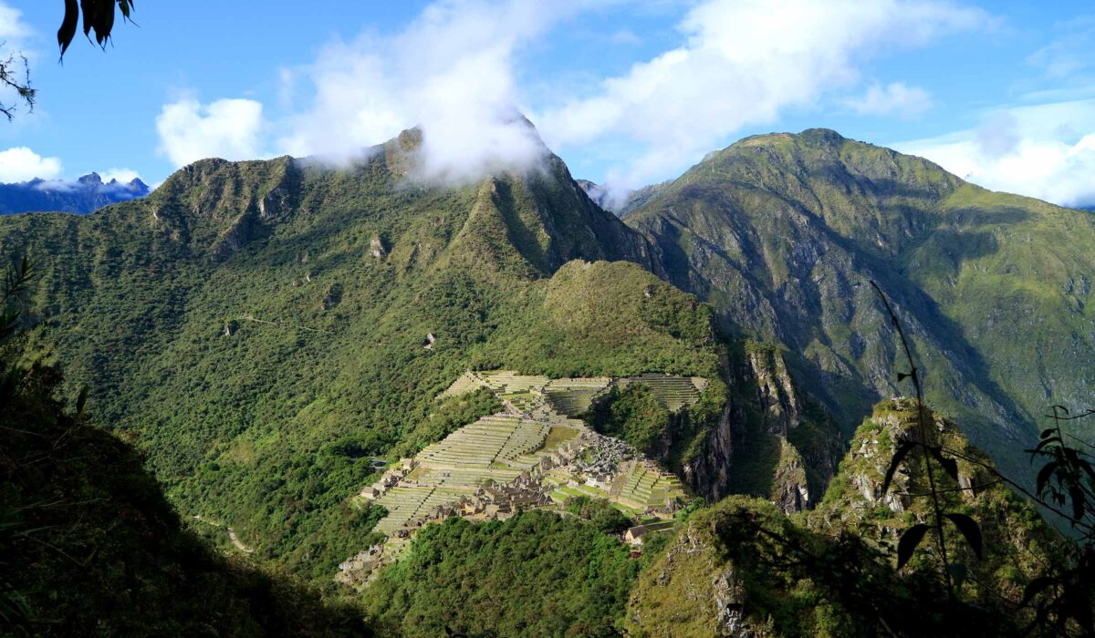
Machu Picchu sits at 2,430 m (7,972 ft) above sea level, about 970 m (3,180 ft) lower than Cusco, which is at roughly 3,400 m (11,155 ft). So no, Machu Picchu is not higher than Cusco: the citadel stands on a ridge above the Urubamba River as it drops from the Andes toward the Amazon, and the town below it, Aguas Calientes, is lower still at about 2,040 m (6,690 ft). The highest point you can reach on a normal visit is Machu Picchu Mountain, about 3,082 m (10,111 ft). Below is the altitude of every stop on a Cusco–Machu Picchu trip in meters and feet, why the numbers differ between websites, and the order that lets you sleep low first.
- 2,430 m(7,972 ft): the Machu Picchu citadel, the standard figure used in our route profiles.
- ≈970 m(3,180 ft) lower than Cusco: you go down, not up, on the way to Machu Picchu.
- ≈3,082 m(10,111 ft) at the top of Machu Picchu Mountain, the highest summit open to visitors on a citadel ticket.
Machu Picchu and Cusco elevation: every stop in meters and feet
Most travelers pass through the same places: they land in Cusco, spend time in the Sacred Valley, take the train from Ollantaytambo to Aguas Calientes and go up to the citadel. Here is each stop, ordered from highest to lowest, with how it compares with Cusco.
| Place | Meters | Feet | Compared with Cusco |
|---|---|---|---|
| Chinchero (on the road to the Sacred Valley) | 3,762 m | 12,343 ft | 362 m (1,188 ft) higher |
| Cusco (city) | ≈3,400 m | ≈11,155 ft | — |
| Cusco airport | 3,310 m | 10,860 ft | ≈90 m (295 ft) lower |
| Machu Picchu Mountain (summit) | ≈3,082 m | ≈10,111 ft | ≈318 m (1,043 ft) lower |
| Pisac (town and market) | 2,972 m | 9,750 ft | 428 m (1,405 ft) lower |
| Urubamba | 2,871 m | 9,419 ft | 529 m (1,736 ft) lower |
| Ollantaytambo (train station) | 2,792 m | 9,160 ft | 608 m (1,995 ft) lower |
| Sun Gate (Inti Punku) | 2,720 m | 8,924 ft | 680 m (2,231 ft) lower |
| Huayna Picchu (summit) | ≈2,693 m | ≈8,835 ft | ≈707 m (2,320 ft) lower |
| Huchuy Picchu (summit) | ≈2,497 m | ≈8,192 ft | ≈903 m (2,963 ft) lower |
| Machu Picchu (citadel) | 2,430 m | 7,972 ft | 970 m (3,182 ft) lower |
| Aguas Calientes (Machu Picchu Pueblo) | ≈2,040 m | ≈6,690 ft | ≈1,360 m (4,460 ft) lower |
Cusco, Sacred Valley, Sun Gate, Machu Picchu and Machu Picchu Mountain: our route profiles and tour pages. Airport: published aeronautical elevation (SkyVector). Aguas Calientes and Huayna Picchu: Wikipedia; Huchuy Picchu: hiking guides. Summit figures are approximate and vary between sources.
Everything you visit at Machu Picchu, including the two famous peaks, is lower than Cusco, and the lowest night of the trip is usually Aguas Calientes, about 1,360 m below the city.
Why Machu Picchu is lower than Cusco
Because Machu Picchu looks like it floats among the peaks in photos, many travelers expect it to be the high point of the trip. Geography says otherwise. Cusco was built in a high Andean valley. Machu Picchu was built on the far side of the Sacred Valley, where the Urubamba River (called the Vilcanota upstream) cuts down the eastern flank of the Andes. According to Wikipedia’s summary of the river, the Urubamba later joins the Tambo to form the Ucayali, a headwater of the Amazon. In other words, the closer you get to Machu Picchu, the closer you are to the Amazon basin, and the lower you are.
You can follow the drop on the train: Ollantaytambo station sits at 2,792 m, and about 750 m lower the train arrives in Aguas Calientes, in the river canyon. The citadel stands on a ridge between the peaks of Machu Picchu and Huayna Picchu, almost 400 m above the town, with cliffs that drop about 450 m (1,480 ft) to the river on three sides. That is why the setting looks so high: what you see is the depth of the canyon, not the height above sea level. The same position on the edge of the Amazon slope explains the cloud forest around the ruins, the humidity (often 80–90%) and the green, steep mountains you see in every photo.
Why the numbers vary from website to website
If you search for “Cusco elevation” or “Machu Picchu altitude in feet”, you will find figures that do not match. That is normal, and it rarely matters for planning:
- CuscoThe city spreads up the slopes of its valley, so the figure depends on where it was taken. Wikipedia gives 3,399 m, the CDC’s Peru page uses 3,339 m and the airport is at 3,310 m. We round to about 3,400 m, as on all our pages.
- Machu Picchu2,430 m (7,970–7,972 ft) is the standard figure. You will also see numbers between about 2,400 and 2,470 m, partly because the site is spread over terraces on a slope, so the upper and lower sectors are at different heights.
- Huayna PicchuThe summit is a narrow ridge, and published figures range from about 2,667 m to 2,720 m. Wikipedia gives 2,693 m (8,835 ft), about 260 m (850 ft) above the citadel, and PromPerú gives 8,750 ft. Any of them means a climb of roughly 250–300 m.
The peaks around the citadel: how high you climb
Since June 2024, each extra climb at Machu Picchu is a separate route with its own ticket and entry time, as we explain in our guide to the Machu Picchu circuits. What matters for your legs is not the summit altitude but how much you climb from the citadel:
| Climb | Summit | Above the citadel | Route and approx. time |
|---|---|---|---|
| Huchuy Picchu | ≈2,497 m / 8,192 ft | ≈70 m (220 ft) | 3-D · ≈1.5 h · high season only |
| Huayna Picchu | ≈2,693 m / 8,835 ft | ≈260 m (850 ft) | 3-A · ≈3 h |
| Machu Picchu Mountain | ≈3,082 m / 10,111 ft | ≈650 m (2,140 ft) | 1-A · ≈4 h |
Routes and times from the official Machu Picchu route list, as summarized on our circuits page. Summit altitudes vary between sources.
Huayna Picchu is shorter and lower, and what makes it hard is the steepness of its steps, not the altitude; we go through it section by section in Huayna Picchu “Stairs of Death”: is it dangerous? Huchuy Picchu is the gentlest of the three. If you want to add one, Huayna Picchu or Machu Picchu Mountain costs US$80 with us, subject to availability.
The Inca Trail: the only part of the trip above Cusco
If you walk to Machu Picchu on the Classic Inca Trail, the altitude story changes for one day. The trek starts at Km 82, about 2,720 m, sleeps at Wayllabamba (≈3,000 m), crosses Dead Woman’s Pass at 4,215 m (13,828 ft) on day 2 and spends one night at Pacaymayo (≈3,600 m), the only campsite higher than Cusco. On day 3 it drops to Wiñay Wayna (≈2,650 m), and on day 4 you reach the Sun Gate at 2,720 m and walk down to the citadel. The night-by-night profile, with distances, is in our Classic Inca Trail day by day.
The Short Inca Trail (2 days / 1 night) is a very different hike in altitude terms: it starts at Km 104 (2,100 m / 6,890 ft), tops out at the Sun Gate (2,720 m) and you sleep in a hotel in Aguas Calientes. It never goes as high as Cusco. It runs from US$520 per person for 2026 departures. We compare both treks in 2-day vs 4-day Inca Trail.
What each place feels like
- Cusco · ≈3,400 mThe altitude most visitors notice. Cusco’s streets are steep, and climbing stairs or walking uphill leaves you short of breath for the first days. The sun is strong at this altitude and nights are cold, above all around June and July.
- Sacred Valley · 2,792–2,972 mNoticeably easier than Cusco. According to PromPerú, temperatures range from about 1 °C (34 °F) before dawn to 20 °C (68 °F) at midday. Chinchero, on the plateau above, is the exception: at 3,762 m it is higher and colder than Cusco.
- Aguas Calientes · ≈2,040 mThe lowest stop. A river town in a deep, green canyon, it feels warmer and more humid than Cusco, and many people sleep better here.
- Machu Picchu · 2,430 mEasier to breathe than in Cusco, but the site is all terraces and stone stairs, so you still work. Expect humidity, strong sun and rain at any time of year; bring layers and rain gear.
- Dead Woman’s Pass · 4,215 mThe one place where the thin air really slows everyone down. You spend only a short time at the top before descending.
In what order to plan your trip: sleep low first
Flights land in Cusco, so everyone starts high. The trick is not to stay there on your first nights. The US Centers for Disease Control and Prevention (CDC) notes in its Yellow Book that, in places like Cusco, travelers can sleep 1–2 nights at elevations lower than the airport before going higher. The Sacred Valley and Aguas Calientes make that easy. Three common ways to order the trip:
- Machu Picchu without the trek: low first, Cusco lastFrom the airport, go straight down to Urubamba or Ollantaytambo for one or two nights, take the train to Aguas Calientes, visit Machu Picchu the next morning and only then return to Cusco. Our Sacred Valley tour with the Machu Picchu connection follows this order: valley, train, hotel night in Aguas Calientes and the citadel the next day. You arrive in Cusco after several days at lower altitude.
- With the Inca Trail: valley, then Cusco, then the trekStart in the Sacred Valley, move up to Cusco for at least two nights and start the trek well adjusted. Our altitude sickness guide has a day-by-day plan for this.
- Short on time: a day trip from CuscoOur full-day tour to Machu Picchu by train (from US$295) takes you down to the citadel and back to your hotel in Cusco the same evening. You spend the day about 1,000 m lower, but you still sleep in Cusco, so give yourself at least a day in the city or the valley before it.
Whichever order you choose, save the hardest walking (Machu Picchu Mountain or the Classic Inca Trail) for after a few days in the region, and pack for two climates: dry, cold nights in Cusco and the valley, humid and often wet days at Machu Picchu. If altitude is your main concern, tell us when you book and we will suggest the order that suits you. For flights and vacation days, see planning the Inca Trail from the USA; for the valley’s towns and map, our Sacred Valley guide.
What about altitude sickness?
The CDC considers any unacclimatized traveler heading to a sleeping altitude of 2,450 m (8,000 ft) or more to be at risk of altitude illness, and its Peru page names Cusco as a destination where travelers are at risk. Cusco and the Sacred Valley are above that line; Aguas Calientes, where you sleep before or after Machu Picchu, is below it. Symptoms, warning signs, medication and a 3-day acclimatization plan are covered in our guide to altitude sickness on the Inca Trail; talk to a travel-medicine doctor before your trip, especially if you have heart or lung conditions.
Frequently asked questions
What is the elevation of Machu Picchu in feet?
Is Machu Picchu higher than Cusco?
What is the elevation of Cusco?
How high is Huayna Picchu?
What is the highest point you can reach at Machu Picchu?
Will I feel the altitude at Machu Picchu?
Should I go to Machu Picchu before or after Cusco?
Is the Inca Trail higher than Cusco?
About the author
Raquel Sánchez co-founded Terra Quechua Peru in Cusco in 2012 together with Edwin Medina, both with extensive trekking experience. She writes our Inca Trail guides from the day-to-day work of securing permits and organizing every departure with our guides, cooks and porters.